Spring 2025 Utah, 4.16.25 - 5.14.25, Part 9, Hanksville, Long Dong Silver, Moonscape Overlook, Cow Dung Road
It was now Sunday, May 4th. We packed up and left Natural Bridges and headed back to Hanksville where we planned on staying for the next four nights. The drive back up US 95 allowed us to see all those sights we passed on the way down one more time. But after having mostly great weather so far on this trip, it finally caught up to us. The rain started as we drove up past the Irish slots but it cleared up by the time we made it to Hanksville.
Hanksville is an interesting town. There is not a whole lot to it. It has an RV Park, a couple of restaurants, gas and a small grocery store and that’s about it. The area closely surrounding the town is not particularly scenic. I think most people just pass through. It is a very central hub. Going south takes you to Lake Powell. Going north takes you to Goblin Valley and on to Moab. Head west and Capitol Reef isn’t far away. Yet all around the Hanksville area are many hidden gems. It was well worth our time to base ourselves there and that we allowed time to explore these treasures. In my pre-trip research I had a number of places I specifically wanted to see. However, the forecast called for likely rain showers for three out of the four days we would be here. With the rain, muddy roads could also be an issue. Many of the roads are dirt roads on bentonite clay and when bentonite gets wet it is impossible to drive on, even with 4WD. The clay sticks to your tires until there is no tread at all and the surface is so slippery it’s like driving on ice. To make a long story short, we weren’t sure what if anything we would be able to see during our stay.
The Hite Bridge over the Colorado River
The Colorado River at Hite Crossing
No better way to combat bad weather than with a shake from Stans Burger Shak!
After getting the Navibahn checked in at Dukes RV Park, we had to find something to do. The weather looked really black and nasty south of us but it wasn’t currently raining where we were so we decided to do a reconnaissance mission to Factory Butte and Moonscape Overlook. Our original plan was to do a one night jamping trip at Moonscape Overlook. I had seen a photo of this place several years ago and was blown away by how incredible it looked there. It had long been on my list of places I had to go photograph, especially at sunrise. With the rainy forecast, I already scrapped the jamping plan but I was really hoping to at least get an opportunity to drive there before sunrise for a photo session on one of the days. Rolling the dice, we drove the Jeep about eleven miles west of Hanksville to the turnoff for Factory Butte Road. Along the way the rain moved in so we had to throw in the towel and just drove back to camp. It rained most of the rest of the day. Heavy sigh.
I expected to sleep in the next morning but it hadn’t really rained during the night and by five-thirty as it began to get light there were clouds but not too thick. I thought there could be a possibility of some epic morning colors if the sun would poke through those clouds so I jumped out of bed (Bridgit was having none of this) and drove seven miles west of Hanksville to an unmarked non-descript turnoff. Luckily, the ground was still dry. I drove a barely visible dirt track two miles until I reached a log fence that stretched all the way across the valley. This was the trailhead for Long Dong Silver.
Long Dong Silver is a remarkable spire situated near the head of a valley surrounded by cliff walls on both sides. It stands on a hill in an area seemingly devoid of all life. No plants, animals, not even any color other than dark shades of grey. It definitely has an aura of mystery and intrigue. Not long ago you could drive right up to it but all the yayhoos tore up the landscape until they finally put up a fence (thank you!) which made it a mile walk to get to the spire.
Probably in part to it being a rather gloomy morning, I was the only one there. You can not see Long Dong Silver from the trailhead because it resides around a curve in the valley. As I hiked in, I passed by another pillar off to the west side of the draw called the Angel Of Death. I didn’t hike over to it since I wanted to be at Long Dong Silver before sunup. As I got further up the valley and rounded a corner, the tall thin spire appeared. I had read that the best spot to photograph was from a hill back behind the spire. As I climbed the hill the ground was a bit softer and while it wasn’t flat out muddy, I did get my shoes caked with moist dirt.
From my perch I now had the classic view of Long Dong Silver rising in the center of what now looked like a canyon, the spire appearing impossibly thin from this vantage point. I waited around to see if the sun would poke through and give the clouds color or light up the spire but neither of these things happened. What I did get though was Long Dong Silver in a great setting, all moody with darker skies and ominous clouds all around. I found that shooting in black and white fit the mood so I experimented with both color and monochrome shots.
Early morning approach to Long Dong Silver
Long Dong Silver
Long Dong Silver
It was so great being the only person in the vicinity. It felt like such a mysterious place and I enjoyed the atmosphere. Back at the Navibahn, we had breakfast and contemplated our next move. It still hadn’t rained this morning so we thought we’d try again to get to Moonscape Overlook. My master plan was to shoot it at sunrise, but with all this iffy weather, I would take whatever I could get. We drove back out to Factory Butte Road and this time we were able to turn off the highway and drive up past Factory Butte to a side track that led out to Moonscape Overlook. By now it had started sprinkling but we could see sun shining on the San Rafael Reef. Black clouds painted a very ominous backdrop to the cliffs in the distance and even lightning bolts cut through the blackness. It all had incredible potential for some really epic lighting conditions. Yet as we drove the short last stretch out to the rim of Moonscape Overlook, the clouds unleashed and the rain started getting heavier by the minute. A couple of spots along the road were a bit slick but we had no trouble getting to the overlook. At about the same time, a guide with some clients also pulled up so we weren’t alone. We all got out and began to check out the views. We only stayed for a few minutes and snapped a couple of quick shots before deciding it might be prudent to get the hell out of there before we got stuck, got hit by lightning or both. Still, it had been a very helpful trip in that we now knew what the Factory Butte Road was like, where the turnoff to Moonscape Overlook was and the condition of that road as well. Hopefully we would get another chance to get out there under better conditions.
The San Rafael Reef provides a backdrop for the moonscape below the overlook (Bridgit photo)
It’s easy to see why they call it Moonscape Overlook
Looking down from Moonscape Overlook
The view from Moonscape Overlook. The rock pedestal in the foreground is a popular Instagram spot where people walk out and stand. Not me.
With the harder rain, it was a bit tricky getting back out to Factory Butte Road from Moonscape Overlook, but once there the road conditions were much improved back to the highway. It rained quite a bit after that so we just hunkered down at camp. By two-thirty it was all sunny again but our shoes were totally caked with morning mud and the ground wasn’t much better. We waited around until six-thirty and then drove out about three and a half miles west of Hanksville to Cow Dung Road (who comes up with these names!). Cow Dung Road is another bentonite clay road that winds its way back to an interesting place called the Mars Research Station. It is a scientific research station that picked this spot due to the area being about as close to what the surface of Mars is like here on Earth. It is not open to the public but you can drive right past it and see little spacemen running around in their Mars suits living in Mars pods and driving Mars golf carts.
For the general public, Cow Dung Road also leads to several areas of beautiful multi-colored bentonite hills and even further, an active dinosaur quarry with even more geologic wonders. That’s where we were headed. The road had several wet spots but mostly it was easy to navigate. Around the three mile mark things got quite a bit sloppier so we decided not to risk getting stuck and turned around. A short way back was an area with some bentonite hills so we stopped and I wandered around during the golden hour taking photos. I would have liked to have seen the areas further down that road by the quarry but that will have to be on another trip.
Bentonite hills on Cow Dung Road
Bentonite hills on Cow Dung Road
Bentonite hills on Cow Dung Road
Bentonite hills on Cow Dung Road
Bentonite hills on Cow Dung Road
Considering this day looked like a total bust I got quite a bit done.
The next morning was completely clear so I made Bridgit get up to see if we could catch sunrise at Long Dong Silver since she hadn’t been there yet. We drove out to the turnoff but the turnoff and the road beyond were both just a muddy mess. It looked like we would get stuck for sure just trying to reach the trailhead. Since it wasn’t that much further, we thought maybe Moonscape Overlook would fare better. Factory Butte Road was pretty dry but as soon as we turned off on the side road to Moonscape Overlook the road conditions deteriorated. We didn’t even try to drive out there. But sometimes rain is just another word for opportunity. On the Moonscape Road right near where it meets Factory Butte Road, a large rain puddle was right in the middle of the road. This provided a fantastic reflection of Factory Butte so we just waited until the sun rose and captured some nice reflections.
Sunrise reflection of Factory Butte
After that, Bridgit hung out at camp so I took the Jeep twenty minutes up the road to Goblin Valley to scope out where we were hoping to camp after leaving Hanksville. There is tons of dispersed camping all around Goblin Valley. With the side roads being a bit wet and muddy, I checked out a first come, first serve campground called Temple Mountain East. It was right past the turnoff to Goblin Valley on the Temple Mountain Road and it had two bathrooms, fire rings and picnic tables. Even better, there was hardly anyone there. I felt confident we could get a site there on Friday. As long as I was there I drove a little way up Temple Mountain Road. It turned into a dirt road and a little further up was another campground called Temple Mountain West. It had a great view of Temple Mountain and right past the campground was another road I was hoping to drive on called the Behind The Reef Road. All this scouting was very helpful. On my way back I stopped at a spot along US 24 where there was a nice dune field and got some nice sand dune photos.
Temple Mountain
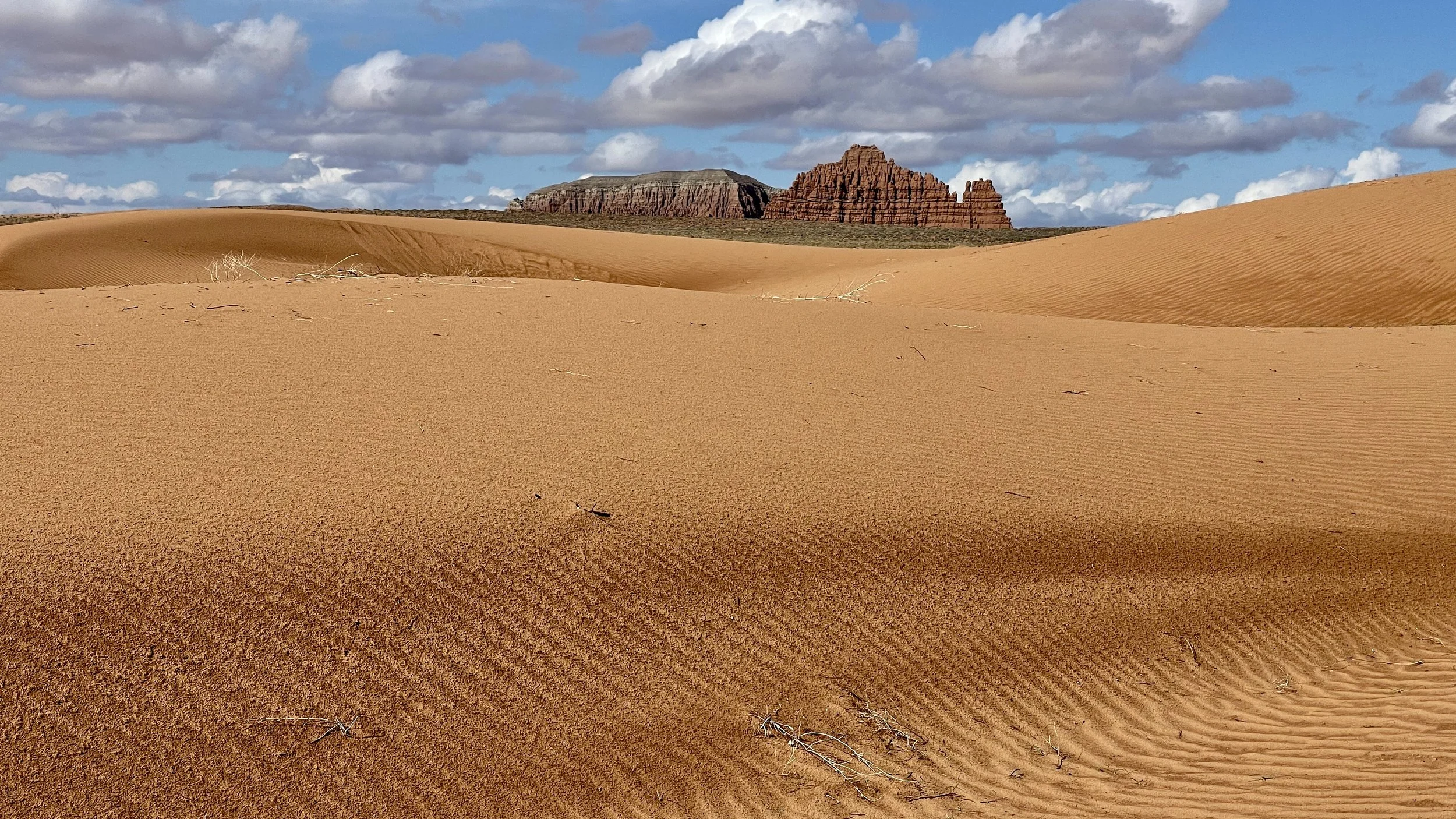
Dune field off US 24
Dune field off US 24
All this took place before noon. There’s more to this day so check out Part 10!