Spring 2025 Utah, 4.16.25 - 5.14.25, Part 14, Goblin Valley State Park, Crack Canyon
On Mother’s Day I figured it would be prudent to let my dear wife and the mother of our dear son sleep in. No getting her up at five for a sunrise hike on this day! She got up on her own about seven-fifteen and we were on the road about eight which is a late morning for us. We drove up Temple Mountain Road and turned left onto the Behind the Reef Road. I had never driven this road and had always been curious about it. I’d done quite a bit of research on driving the full length of it but I think it gets really rough the further you go. It sounds like the kind of road you would maybe need a modified Jeep and go in a group. Our plan was to drive it just the first four miles. It was a bit rougher than Temple Mountain Road. Behind the Reef had sections of slickrock with small shelves to drive over but nothing too difficult. Of course it got its name because it runs behind the San Rafael Reef. This is a tremendously beautiful tilted uplift that runs for about seventy-five miles starting north of I-70 and running south from there. Along the reef, the San Rafael River, Muddy Creek and I-70 cut through the reef and numerous slot canyons with narrow passages and gorgeous high walls can be found. The back side or western side of the reef is very jagged in places since the higher end of the uplift is the western side.
We parked at the trailhad for one of these canyons called Crack Canyon. I have known of this canyon for many years but had never had the chance to hike it. Knowing our itinerary had options for much more than we had time to accomplish, Gary practically insisted that we make time for this one. We were expecting the weather to start turning and get some strong winds later that day but we figured we would be somewhat protected in a canyon and be done before it got too windy.
After our experience in Little Wild Horse Canyon I was concerned that this one might be too much for Bridgit. I knew we would come to several obstacles. some of which were substantial including one bypass rated a class 3 scramble so I figured we would just go as far as we could and if we had to turn around, so be it.
The first half mile is along a 4WD road. My research told me it gets progressively rougher the further you go which is why we parked at the 2WD trailhead. After hiking it, I am positive I would have had no problem driving the 4WD section. We even saw two vehicles camped near the end of the 4WD section. Oh well, the walk was a good way to warm up the legs for the day.
2WD trailhead looking towards Crack Canyon
Hiking along the 4WD road towards Crack Canyon
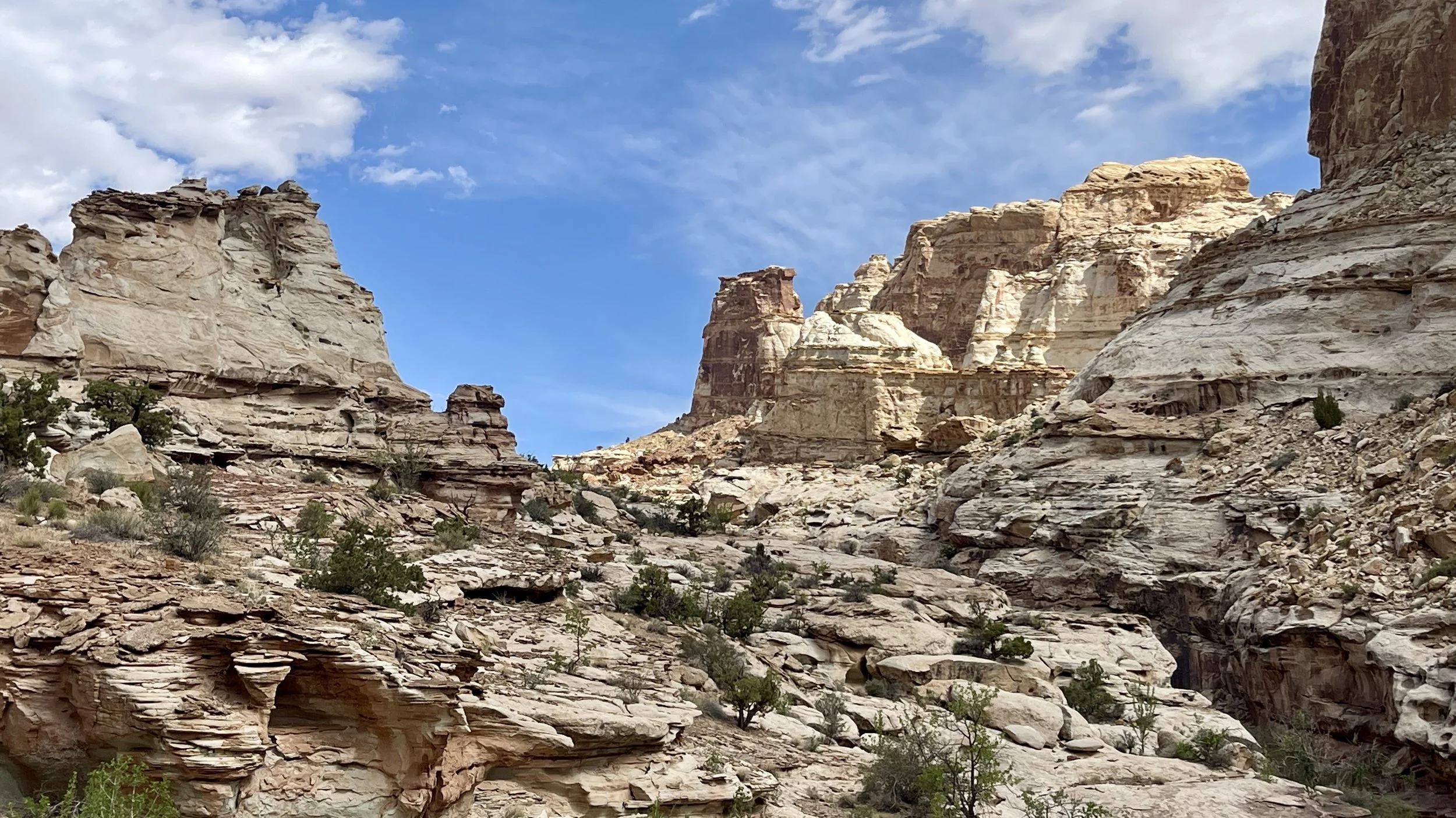
Beautiful uplift of the San Rafael Reef
The 4WD road fizzled out after a half mile and we came to the entrance to Crack Canyon and our first obstacle. A pouroff which is kind of like a dry waterfall (when it’s not raining) blocked our ability to drop straight into the wash of Crack Canyon. An easy bypass along the right side worked around this obstacle and soon we were down in the wash. Because Crack Canyon actually cuts through the San Rafael Reef from west to east, as we began hiking in the wash the walls narrowed up and became very high on either side. Crack Canyon was exquisite. The walls were heavily covered with all sorts of water pockets and multi-colored white and lavender patterns lined the walls along the cliffs. As for hiking, the bottom of the wash was pretty smooth as we made our way down canyon.
I love the contrast of bright green cottonwood leaves with the brown walls of the canyon
High cliff walls surrounded us as we got deeper into Crack Canyon
As we got deeper into Crack Canyon the walls became very water pocked and lots of color lined the base of the walls
Crazy patterns imbedded in the rocks
All created by water and wind
This one looked like an earhole
Soon we came to a particularly stellar set of narrows. This section had overhanging ledges that made it look like we were hiking through a tunnel at times. This was an extremely beautiful section and we lingered here and took lots of photos.
The tunnel section of narrows (Bridgit photo)
So fun to hike through!
The tunnel section in Crack Canyon
The weather was warm and the clouds kept it from being too hot. We were in great spirits as we made our way further down the canyon. It was a beautiful day. Our second obstacle was another pouroff. This one was maybe seven feet high. A log, maybe five inches in diameter and eight feet long had been strategically placed at an angle so by pushing on the sides of the canyon walls for balance, we could simply walk down the length of the log to overcome this obstacle.
Negotiating the log (Bridgit photo)
King of the Canyon (Bridgit photo)
More narrows
More narrows
The next obstacle turned out to be the trickiest one of the day. As we were hiking down canyon we came to a pouroff that was perhaps ten feet high and straight down. We scouted to the left and right but there was no easy way to bypass this spot. Upon further investigation, along the right side there were several small ledges in the cliff. I carefully used these ledges and made it down to the wash below, making sure that we could also climb back up on our way back. Then I helped guide Bridgit’s feet to the key spots and we both easily made quick work of this obstacle. I was super proud of her scrambling skills and taking it on.
More narrows, more beautiful canyon hiking and then we came to the biggest pouroff. I had done a bunch of research about this one. Many people turn around here and some use a rope to continue. Even Gary hadn’t figured this one out yet so he couldn’t advise me and had never been any further down the canyon. But rumor had it that another even more beautiful set of narrows lay on the other side of this pouroff.
My research told me that from the pouroff, if you go back up canyon just a very short way and look to your right (going up canyon) that there was a steep boulder-filled crack. It turned out it wasn’t that hard to find because someone had built a cairn right at the base of the crack. Utilizing all the skills we had obtained through the Mountaineers Scrambling Course, we easily climbed up through the boulders. It was perhaps twenty feet of scrambling. At the top we found a wide rock ledge. Following cairns, we hiked along the ledge for a short way until an easy descent put us back in the wash beyond the pouroff.
The boulder scramble bypass
The boulder bypass showing the rock ledge above the tree.
From the rock ledge bypass looking back up canyon
Descending the bypass back to the wash (Bridgit photo)
Now that we were past the crux of the obstacles we were feeling pretty darn good. More beautiful canyon lay ahead. Soon after, we came to the third and last set of major narrows this canyon had to offer. This last section was tremendously beautiful. The walls were the highest of the entire hike and quite close together making for a very dramatic set of narrows. We really enjoyed this section. At the far end the walls began to open up. From here, the canyon has no more narrows sections as it makes it way a couple of more miles to the lower end of the canyon. You can actually hike up the canyon by starting at the lower trailhead which is off of the Goblin Valley Road. Since we had conquered all the obstacles and seen the best of what Crack Canyon had to offer, we made this our turnaround point and in no particular hurry we worked our way back up the canyon. None of the obstacles presented a problem going back. What is great about canyon hiking is that the views are ever changing. Sometimes things look totally different coming back than they do going down. It was all really great and we really loved this hike.
Looking back up canyon
My happy hiking buddy
The beautiful last set of narrows in Crack Canyon
The last narrows section
The last narrows section
The last narrows section
The end of the narrows section. We turned around just beyond this corner.
Strange water-pocked walls lined the entire route through Crack Canyon
Just amazing!
Bridgit climbing back up the most challenging obstacle
The colors and rock patterns in this canyon were just incredible!
Coming back up Crack Canyon
Coming back up Crack Canyon
Back to the tunnel section (Bridgit photo)
Bridgit in the tunnel section
Back out of Crack Canyon
Map of the area. We were camped just east of Temple Mountain West. The green line is our route down Crack Canyon.
Our hike through Crack Canyon was so great. It had enough challenge to be spunky but not so hard to take away any of the joy. We both thought this was one of the better hikes of the trip. Not that any were less than great, but we really enjoyed this one.
As expected, the winds really picked up by the time we got back to the trailhead. The forecast called for thirty-eight mph gusts and strong winds throughout the next day which was our last day before heading for home. Luckily, where we were camped it wasn’t sandy so at least we weren’t in a dust storm.
There were a few clouds to the west that evening so I was prepared for another possible nice sunset from our campsite but then I turned around and the moon, just one day from being full was rising right over the rocks by our campsite. I ran and grabbed my tripod and long lens and got a good moon shot. As you will see in the final installment, it’s a good thng I did.
Almost full moon over our camp