Spring 2025 Utah, 4.16.25 - 5.14.25, Part 6, Capitol Reef National Park, Burr Trail, Halls Creek Overlook, Bullfrog Canyon Overlook
The day after we hiked Cohab Canyon was a Sunday. It was really cold and windy and since we were waiting to deal with the tires until Monday, it was a perfect day to take a break and recharge. Bridgit got some laundry done, I practiced guitar for an hour or two. I also wandered across the street to the Wayne County Visitor Center. I recognized the guy behind the counter from our previous visit there. His name is Clark and he is a wealth of good information about the entire area. We talked for over an hour about all kinds of hidden places. I think he enjoyed chatting with someone with a better knowledge of the area rather than just telling tourists how to get to the pie place.
That evening another dear friend Harry and his wife Annie arrived. They were on their way home in California from Denver and could only stay the one night. We grabbed some delicious burgers from Capitol Burger and brought them back to the Navibahn. We only saw them for a couple of hours but it was a great visit.
Monday the 28th was a busy day. We had to check out of Wonderland RV Park and move to the Fruita campground, but we also had to deal with the tires that morning. We moved out and parked the Navibahn at the visitor center. Rather than go all the way to Moab, we decided to head to Ritchfield which was a little over an hour away. We got great service at Big-O Tires in Ritchfield. They said the tire couldn’t be repaired. Since they didn’t carry the same tires I had on the Jeep, we ended up buying a whole new set of tires. These were made by BF Goodrich and they told me I’d be much happier with them. Apparently my old tires were only four ply and these are six ply. While there we also used the best of my old tires for a new spare since the sizes matched.
We were all set by noon with a brand new set of tires. I was so relieved since we had a major Jeep excursion planned for the next day. We drove back and got the Navibahn set up at the Fruita Campground. Then we ran over to the Gifford House and grabbed the last of the mixed berry pies and took them back to our camp. We packed up all our camping gear into the Jeep and got ready for a one night jamping (Jeep camping) trip the next day.
Tuesday morning we left the Navibahn at Fruita and drove the Jeep to Torrey. We topped off the gas and bought a bundle of firewood to use when we got back to Fruita since they have fire rings. Then we turned onto US 12 and headed back over the mountains and down to Boulder Town. In Boulder we turned off onto the Burr Trail. This is a mostly paved road that runs through a part of Capitol Reef we had never seen. Our plan was to drive the Burr Trail east, stopping at some points along the wasy until it dropped down the Burr switchbacks to the Notom Road. We would then turn south towards Bullfrog Marina on Lake Powell but then take a short Jeep road out to a spot called Bullfrog Canyon Overlook. This was a very obscure spot that I found on my Gaia app. It isn’t really listed on any of the park maps and there was no information I could find on the internet about it. But based on my map, it looked like it would be a spot we could camp on the rim of a canyon so thought it would be worth checking out. If it didn’t work out, we could camp at the campground down at Bullfrog on Lake Powell. Then the next morning we would check out Lake Powell and then drive north on the Notom Road all the way back to US 24 and back to Fruita.
The classic barn shot in the Fruita District
From Boulder we drove east on the Burr Trail, dropped down to the Notom Road and camped just south of where the map ends.
As soon as we turned onto the Burr Trail, we drove past a huge golden mesa of slickrock.
Near the beginning of the Burr Trail
Our first ooh aah moment came when we reached an overlook above Long Canyon. We had a great view looking straight down the canyon. Then we dropped down and drove right through it. Beautiful!
Long Canyon
We dropped into Long Canyon and flanked by high orange cliffs on both sides, we stopped eleven miles from Boulder at an unmarked pullout. Just off the road here was a short slot canyon called Singing Canyon. There were no trail signs but I had found this in my pre-trip research. The hike is only a couple of hundred yards long, but the walls are very high and bright green cottonwoods add contrast to the orange walls. It is called Singing Canyon due to the unusually great acoustics inside the canyon. I had almost considered bringing my guitar and playing a tune or two but decided not to bother.
Singing Canyon
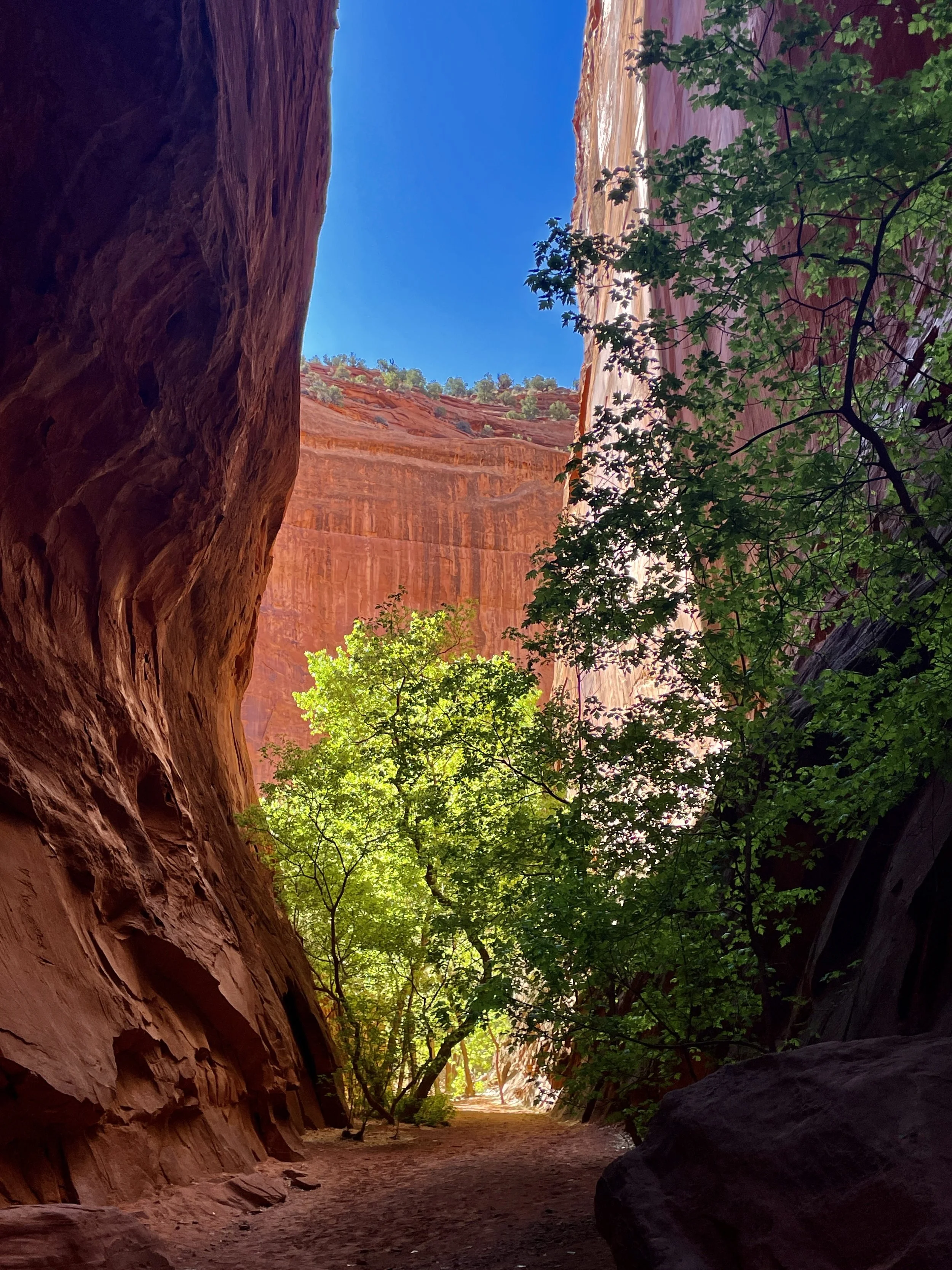
Singing Canyon
Back on the Burr Trail, the scenery was simply outstanding and we stopped numerous times for photos. At 32.8 miles from Boulder, shortly after the road became a dirt road we came to the turnoff to Upper Muley Twist Canyon. This 4WD road goes 2.9 miles up a narrow canyon wash past a couple of arches to a trailhead called Strike Valley Overlook. The weather was great, we were both giddy with the adventure bug so we threw the Jeep into 4WD and turned up the wash. Even from the turnoff we could see a large window in a white cliff up ahead. The road was bumpy and a bit rocky but nothing too difficult as we made our way around tight corners and up the middle of the wash. After rounding several turns we came upon Trinity Double Arch on our left. We had to stop and hike up underneath it to fully see both arches. Before long we made it to the Strike Valley Overlook Trailhead. There was one other vehicle there but no sign of its owner.
We set out on the very short .4 mile hike to the overlook. This was a fun easy trail that led to a large hill comprised of solid slickrock. When hiking on rock there is no trail to follow so typically either the park service or elves place small rock piles called cairns to mark the route. We followed the cairns up to the top of a rock ridge and then to a point on the edge of the rim of a cliff. From this fine vantage point we were looking down into Strike Valley, where the Waterpocket Fold stretched out to the north and south as far as the eye could see. Being the only people up there made it feel even more adventurous.
The beautiful Burr Trail
Along the Burr Trail
Just near where the road turns to dirt
The turnoff to the 4WD Upper Muley Twist Canyon
Upper Muley Twist Canyon
Trinity Double Arch
On the Strike Valley Overlook trail
The incredible Strike Valley (Bridgit photo)
Strike Valley looking north
Cheerios Double Arch
Window on Upper Muley Twist Canyon
We drove back out to the Burr Trail and soon came to the Burr switchbacks. This was a large gash in the Waterpocket Fold and a series of switchbacks dropped down through the gap to the Notom-Bullfrog Road. The switchbacks were pretty tame compared to the Shafer switchbacks in Canyonlands, but they were still exhilarating. The rock on either side of the switchbacks was very contorted and looked tremendous.
The top of the Burr switchbacks
The Burr switchbacks
Once down the switchbacks at the junction, the Burr Trail goes south but if you go north it becomes the Notom-Bullfrog Road. We turned right and headed south and after that we only saw one person the rest of the day and night until we reached Bullfrog Marina the following morning. We were planning to drive directly to our campsite but several miles down the road off to the right the rocks were looking particularly cool. We came to a turnoff heading that way that said Halls Creek Overlook. I had researched this spot prior to the trip and knew that there is a great backpack trip down through Grand Gulch to the Halls Creek Narrows. We still had time on our hands so we turned off and headed towards the overlook. It was 2.3 miles to another turn and then just .3 miles to the overlook. The 2.3 section is called Big Thompson Mesa Road. It was a pretty rough road and had numerous rocky hills to climb but it was no problem in the Jeep. I love our Jeep by the way.
When we got to the overlook we were surprised to find a vehicle there. The owner, Jim from Florida, had just come out from a solo two or three night backpack down Halls Creek on the Grand Gulch Trail. I’ll bet it was amazing and I’m sure he didn’t see anyone else. This is a very remote area. My balls aren’t big enough to do a solo backpack in a region that remote. Kudos to Jim!
Rock along Hall’s Creek/Grand Gulch
Upper Hall’s Creek
Hall’s Creek/Grand Gulch
Brimhall Arch is a 4.8 mile out and back from Hall’s Creek Overlook
Back on the Burr Trail, we continued south several more miles until we came to our turnoff to Bullfrog Canyon Overlook. This was 19.1 miles south of the bottom of the Burr switchbacks and the road was BLM 12070. The short 1.1 mile road took us out to what turned out to be one of the best campsites we’ve ever stayed at. When we got there, not only was no one else there, but as mentioned, other than Jim we hadn’t seen even one car since turning off the Burr switchbacks.
The site was around a corner in a very large flat area with a big rock fire ring right near the edge of a cliff. The view from the rim was looking straight up into Bullfrog Canyon with the Henry Mountains looming above the head of the canyon. A mostly dry Bullfrog Creek twisted and turned as it wound its way through the canyon with sheer walls rising on either side. It was just breathtaking. I knew right then we had found maybe the sweetest campsite ever. It was out of this world gorgeous.
We set up the tent on a nice flat spot but since it was all rock we held the stakes down with heavy rocks. It was still only three so we had hours to just relax. We had everything we needed. We had brought a cooler with ice, cold drinks, food and we were happy campers. We set up our camp chairs right out on the rim and had a delicious dinner of chicken tenders, antipasto salad and strawberries while we gazed up the canyon as the sun slowly sank.
After dinner we took a walk. From our site we followed the rim a short way to the south and much to our pleasure, this opened up an entirely new view of Bullfrog Canyon looking south. In writing this I still can’t quite get over what a stunning setting our campsite was. I shot photos all evening through the golden hour until after the sun set which was at 8:09PM. Then to make a perfect situation even better, we remembered that we had bought wood for after we got back to Fruita. Well needless to say, the wood never made it back to Fruita. We had the most romantic crackling fire after the sun went down and the stars began to come out. If there is such a thing as a perfect camping trip, this was it.
In the morning of course I was up before dawn and shot sunrise from both sides of the canyon. Then we had some breakfast, packed up and continued south until we reached Bullfrog Marina at Lake Powell. The scenery along the way was still really great. At Bullfrog there wasn’t any grand vistas so we talked to a ranger who showed me an option for a road that led to an overlook not too far from Bullfrog. We drove up 276 past the turnoff to Burr Trail and turned onto a non-descript dirt road. Another turn was supposed to lead to the overlook but the further we drove, the deeper the sand got until we came over a rise and the road just flat out ceased to exist. It was really deep sand all around and we were in a bad spot to get stuck. We had to get turned back around the other way so we got out and checked around. One side seemed a bit harder packed than the other so Bridgit guided me as I made numerous short turns to try and get pointed the other way. We did manage to do that but came extremely close to burying the wheels in sand. From that point I had it in 4L. I also could have aired down a lot (I have a compressor in the Jeep), but we managed to finally get moving back and made it out of there on our own. Whew. I think that was my worst experience so far with deep sand and I didn’t like that at all. And for all that, there was nothing remotely close to a view where we ended up.
We drove all the way back north on the Burr Trail and Notom-Bullfrog Road. I was a little disappointed that it didn’t seem as spectacular along that road as I hoped it would be. But no matter, I was still so pleased with our campsite overlooking Bullfrog Canyon that nothing could have burst my bubble at that point.
The view from our campsite looking up Bullfrog Canyon
A short walk from our site looked south down Bullfrog Canyon
Evening light on Bullfrog Canyon looking south
Our toasty fire overlooking Bullfrog Canyon with the Henry Mountains behind
Sunrise looking south down Bullfrog Canyon
Early morning looking north up Bullfrog Canyon
So our jamping trip to Bullfrog Canyon Overlook wrapped up an incredible visit to Capitol Reef National Park. We both dearly loved Capitol Reef. Even after two separate visits totaling twelve days, there is still plenty we left on the table. We would gladly go back to see and do more. You don’t hear as much about Capitol Reef as the other parks of the Mighty Five (Zion, Arches, Bryce and Canyonlands), but Capitol Reef is every bit as glorious as the best of the rest of Utah’s amazing collection of National Parks.